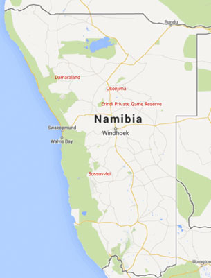
Janice and I visited Namibia from 5th to 20th November 2013.
Namibia straddles the Tropic of Capricorn, which passes a little to the south of Windhoek, and is very dry with an arid (evaporation exceeds rainfall) to semi-arid climate over the whole country, apart from the far North. The coastal Namib Desert receives no rainfall at all in some years. The weather on the coast is determined by interaction between the inland warm dry winds and the Benguela Current (cold water direct from the Antarctic) leading to invariable moist fogs every morning. The only rivers which are permanently water-filled are on the Northern (Kunene river) and Southern (Orange river) national borders.
We flew overnight from London Heathrow to Johannesburg with Virgin VS601 on the 5th November and then by Air Namibia SW724 to Windhoek. We spent the night in the Olive Grove Guesthouse, located in the suburbs and thus too far from the centre to explore Windhoek.
The great majority of our fellow tourists were German speakers.
7th November: From Eros Airport we were flown by Wilderness Air 12-seater Cessna 208B Caravan light aircraft to Geluk Airstrip, a short drive from
10th November: Flight by Cessna Caravan from Geluk, via a refuelling stop at Swakopmund, to the airstrip a short drive from
14th November: Flight by 5-seater Cessna 210N to
17th November: Road Transfer to
The first two camps were intended to allow us to see the desert landscape that is one of the main geographical features of Namibia. The two remaining camps were game reserves which although large were fenced off from the surrounding territory - as a result, this was where we planned to see and photograph some exotic wildlife.